Geoglyphology, An Ancient Science Rediscovered
Arthur D. Faram
Faram Research Foundation – Arlington, Texas
Recently Arthur Faram, while investigating his Celtic Genealogy, discovered an ancient and historically revealing science.
After determining that this science had not been mentioned in any previous publications, The Faram Research Foundation named the ancient science Geoglyphology. “Geo” for earth, “glyph” for writing and “ology “ for the study of… . The original function of Geoglyphology, by the ancients, was to mark and claim territories. Since its rediscovery, this ancient science has been used to expand both the search area and the knowledge base available to the Archeologist and related disciplines. In addition, since the science was primarily used to mark large territories, claimed by the originator of the geoglyph, the resultant findings are rewriting history.During our research it was discovered that ancient civilizations have, for millennia, passed down a previously unidentified science which was used to outline the boundaries of ancient civilizations, around the world. During their constant battle to expand, control and identify their territories, ancient civilizations have left a legacy of geoglyphs on the shores and highlands of land masses, and islands, around the world.
A well-known example of a geoglyphic survey marker is the Stonehenge monolith in England. Stonehenge has been known for centuries, as have other monoliths, for displaying astrological alignments which were designed into its construction. The science of studying astronomical alignments within geoglyphic structures has recently been scientifically accepted, having been given the name “Archaeoastronomy”. Until now, the geoglyphic attributes (Geoglyphology), which co-exist alongside the astronomic attributes of these structures, have been overlooked.
Currently, the majority of the information available to the Archeologist is gleaned from the information recovered at the dig site. In recent years, it has been discovered that a great majority of the ancient architectural, monolithic and geoglyphic structures built around the world, have a particular commonality. That commonality is that the structures are aligned in such a manner that the study of their linear alignment unveils a much larger story than can be attained at the dig site. A geoglyphical survey can immensely expand the cultural data available to both the archeologist and the related disciplines.
Geoglyphic studies uncover data that may have otherwise gone unnoticed by the various scientific disciplines working on a site. Data obtained from the geoglyphical study of a site can immensely expand the data available to the Archaeologist. These benefits may include determining the geographical range of the culture being studied, the level of sophistication that existed in relation to their understanding of mathematics and geometry, the cultures knowledge of world geography, the discovery of other archeological sites that were unknown prior to the geoglyphic extension of alignments associated with structures at the site, and the dating of the culture itself by the data collected both at the dig site and offsite locations which have been identified through the use of Geoglyphology. Previous successes, through the use of Geoglyphology, leave no doubt that Geoglyphology can play a major role in expanding the knowledge base available to various scientific disciplines.
Geoglyphology
A geoglyph consists of a large motif, or monument produced on the surface of the earth. This can be accomplished by building or sculpting stone monoliths, arranging patterns of multicolored earth or stones on the earth, or by the wall alignment of buildings such as at Caral, Peru. Through these and other geoglyphical techniques used by the ancients, our predecessors have left a rich history of their existence, and conquests, on our planet.
The practice of marking territories with geoglyphs has been passed down secretly for millennia. Since the practice of Geoglyphology is to mark a claimed territory, the practice would inherently require some degree of secrecy. Most of these survey markers are so large and so spread out, that they remain hidden unless someone that knows of their existence points them out. By being so large they are, for the most part, immune to tampering and remain hidden. When the builder needs to prove their prior claim to a given territory, they have but to point out their geoglyphic survey marker.
Another reason for keeping geoglyphs secret is that, as they are survey markers, they are a written record of the travels and history of the people that constructed them. Therefore, their exposure would be detrimental to any group that did not want ancient history to be revealed.
This ancient science has been used by civilizations including the Portuguese, Celts, Etruscans, Egyptians, Phoenicians, the Japanese and their predecessors. The oldest geoglyphic site confirmed to date is 26,400 years old.
What makes up a Geoglyph?
Glyph – A glyph can be any design that is used to convey a message.
Geoglyph – A geoglyph is a glyph that occurs on the ground.
Bearings – A bearing refers to the direction that any line, formed by a geoglyph, points in relation to “Magnetic North”. Magnetic bearings can be used at the origination point because they have not been distorted by magnetic deviations that exist between the starting point and the destination. A True or direct line is necessary once you depart the origination point because as you begin tracing a line away from the source, magnetic deviation becomes a factor. Magnetic deviation exists all over the world and renders the magnetic heading of a compass useless over long distances because of the error occurring naturally from the magnetism of the earth.
A true heading is the shortest distance between two points without having to consider magnetic deviation. True headings can be scribed on a globe, derived from Celestial Navigation, GPS, and computer software. These methods only produce straight lines which are not distorted by Magnetic Deviation.
Radials – Radials are bearings after they leave the source. At the source, Magnetic Bearings and True Headings are the same. This commonality exists as the result of there being no distortion occurring as a result of moving away from the source site. Once a direction away from the source is plotted it must be plotted on a true course, not a magnetic course, in order to avoid magnetic deviation.
Geoglyphs, for the most part, are so large that they can only be recognized from the air. The civilizations that placed these geoglyphs must have had mathematical capabilities well beyond anything we give them credit for. Some sites have been physically visited on the ground and, even knowing they are there, they are difficult to locate. The glyphs take on several forms. Some take the form of a triangle, another might be one or more circles, and another may be one or more lines touching or crossing each other. No matter what shape a glyph takes, any line can be a pointer to a place important to the creator of that glyph. (See the following chart.)
 Above are a few examples of radials generated by various shapes that may comprise a geoglyph.
After applying the above criteria to a geoglyph it is then necessary to apply certain protocols which have been passed down for millennia from one civilization to another. These protocols allow the user to determine the destination and end point of the bearings emanating from the geoglyph. (Examples below.)
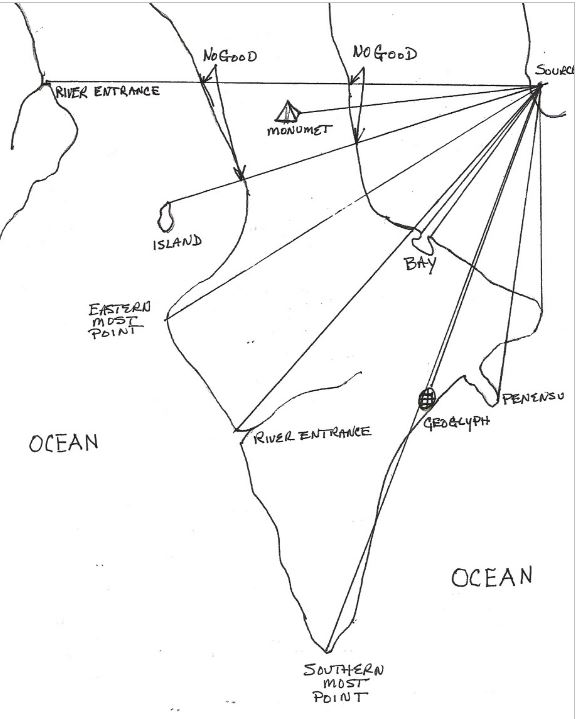
Some examples of the ancient protocols used to verify where the radial of a geoglyph ends.
Once the bearings are established for a geoglyph, at the point of origin, the bearings are extended in the form of radials (True Headings) to determine if, and where, they intersect with an object that meets the protocols which were established millennia ago. In order for an extended radial to be considered legitimate it must pass one of the protocols set down by the ancients. These points verify that the radial is legitimate and indicate the endpoint of the radial. A few examples are shown above and can include: the mouth of a river, another geoglyph, a monument, a location sacred to the culture that built the geoglyph and validated by being pointed out by a separate geoglyph, the entrance to a bay, a significant protrusion on a land mass such as the corner or tip of a continent, the tip of a peninsula, an island, or the highest mountain peak in an area. Most geoglyphs are located near water, and point to locations near the water. This would seem logical as the entrance to rivers and bays were the most recognizable geographic points to ancient sailors.
After some study, it was discovered that many mediums were used to construct geoglyphs. These included; the arrangement of stones, the planting of different colors of flora, the sterilizing of the ground, the scraping of the earth to reveal a different color underneath (Nazca), the changing or supplementing of natural geological features, the wall alignment of structures (Caral, Peru), the alignment of Monoliths (Stonehenge), the alignment of Pyramids (Worldwide), the creation of stone and earth mounds, and more. For instance, the edges of the mounds, of the so called Mississippian Culture, in the central and eastern United States have proven to be geoglyphic territorial pointers.
Ancient archeological locations, many previously unknown, have been identified through Geoglyphology. The accuracy of the calculations of the ancient peoples is incredible. The GPS accuracy of the modern software program is seldom more accurate than the orientations of the ancients. By calculating the bearing at the source one can follow the extended radial for sometimes thousands of miles and locate a related geoglyph with little or no error.
The percentage of success in locating a verifiable glyph or ancient location using each of the extended radials of any one glyph was variable, but ran in the range of 90% to 100%. Much of the lack of success was attributed to urbanization, overgrowth, vandalism, etc. Surprisingly, based on the glyphs that were found, there seems to be an incredible amount of durability built into the geoglyphs. It appears that the meteorological conditions at any given site were considered in determining the materials used. At sites where rain and wind are seldom seen, most glyphs were made of earth. At locations that encountered rain and wind, stones and rock were used.
Research results indicate that Geoglyphology holds great promise in expanding our understanding of the civilizations that have preceded us. Through the tireless efforts of many devoted scientists, and the creation of new technology, the world is on the cusp of a new awakening. To some this paradigm change will be quite uncomfortable.
Spherical Geometry
Geoglyphology exists in the world of Spherical Geometry. In Spherical Geometry there are no parallel lines. It is difficult to grasp the concept that two bearings of the same value can cross. That is because we are used to thinking in terms of Plane Geometry on a flat plane. However, all this changes when you draw lines on a sphere. In dealing with a sphere you enter the realm of Spherical Geometry.
Spherical Geometry is the study of figures on the surface of a sphere, as opposed to the type of geometry studied in Plane Geometry or Solid Geometry. In Spherical Geometry, straight lines are great circles; therefore, any two lines will always cross in two places somewhere on the sphere. A good example of this is to look at a globe of the earth. The Longitudinal lines cross at two places, the North and South Poles, however; the Latitudes never cross. That is because the Latitudes are an example of Plane Geometry slicing through the earth, while the Longitude is an example of Spherical Geometry when a line is drawn on the surface of the earth. Accomplished mathematician, as were the ancients, used a line to point to a distant object, or used two lines to come together at a distant point to highlight an important place. (See below.)

The preceding picture demonstrates how two lines, of the same heading, emanating from the same longitude, will always cross at two points on the globe and can be used to point to a specific point on the earth.
In the field of Geoglyphology, we are plotting lines in a spherical world and then displaying the results on a flat plane. The science of Geoglyphology could not have been rediscovered without the advent of the “Google Earth”, or similar, software. Google Earth software computes using Spherical Geometry and then displays the results on a flat plane. This type of precise mapping precludes the plotting of these bearings on a flat map. Maps become distorted when converted from a sphere to a flat map.
GEOGLYPH EXAMPLES

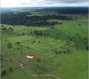
One of Over 300 Known Ancient Geoglyphs Constructed in the Amazon

The Pyramid Geoglyph at Yonaguni, Japan


The compelling question is; what knowledge did the ancients possess that allowed them to do these calculations. The most likely answer is the ancient knowledge passed down by their predecessors, and their obsession with astronomy.
Note: The current calculations performed in Geoglyphology require the use of a special software called “Google Earth”. Google’s software is able to calculate true spherical bearings on the curved surface of the earth and then display them correctly on a flat plane.
Bibliography:
Aveni, Anthony “The Lines of Nazca” Philadelphia (1990)
Faram, Arthur “Ancient Signposts” CreateSpace (2011).
Faram, Arthur “La Merica” Foundation Press, Dallas (2013).
Reindel, Markus/ Wagner, A. /Verlag, Springer “New Technologies for Archaeology: Multidisciplinary Investigations in Palpa and Nazca, Peru” Natural Science in Archaeology, Page 50, (2009).
Haughten, Brian “Hidden History: Lost Civilizations, Secret Knowledge, and Ancient Mysteries” Career Press (2007)
Professor Kennedy, David “Visible Only from Above, Mystifying “Nazca Lines” Discovered in Mideast”, MSNBC (Live Science) 9/15/2011.
Mann, Charles “The Geoglyphs of Palpa, Peru: Documentation, Analysis, and Interpretation” Germany (2008)
Parssinen, Marti/Schaan, Denise/Ranzi, Alceu “Pre-Columbian Geometric Earthworks in the upper Purus: a complex society in Western Amazonia” Antiquity Magazine, Volume 83 (322): Pages 1084-1095.
Reinhard, Johan “The Nazca Lines: A New perspective on their Origin and Meaning” Los Pinos, 6th edition, Lima (1996)
Romero, Simon On Sauerbier, Martin: “GIS-Based Management and Analysis of the Geoglyphs in the Palpa Region” ETH (2009) Amazon Photo by Douglas Engle, N.Y. Times
Romero, Simon “…Amazon’s Lost World” N.Y. Times January 14, 2012
Please click here to purchase Mr. Faram’s most recent book “La Merica”.
