
By Chao C. Chien
Originally published by Diogenes Research.org
In a recent BBC News posting a famous medieval map was once more marveled at. This is the famous 1507 “Map of America” by the German cartographer Waldseemuller (See http://www.bbc.com/news/magazine-30840318).
The 1507 Waldseemuller World Map South America
This map is famous on account of it being the first world map to show the name America. It is now virtually accepted history that the name was derived from an Italian “explorer” named Amerigo Vespucci who allegedly participated in a couple of trans-Atlantic crossings and visited the northeastern coast of South America in the early 1,500. It is said that he came back to Europe and wrote about his adventures. His writings got so popular that when the German mapmaker Waldseemuller got wind of it he put Vespucci’s name on the new continent in his new map. Note that this happened just about 50 years after Gutenberg “invented” the movable type printing press. It had to be a near miracle that Vespucci’s account circulated so widely when the publishing business was still in its infancy. Aspiring writers today can only dream of such success.
How did the name go from Amerigo to America anyway? Well, it is sort of a convoluted story. Supposedly the name was first Latinized from Amerigo to Americus, with the G changing to a C in the process for some reason. Then, because it was a continent—land, it became female; thus America.
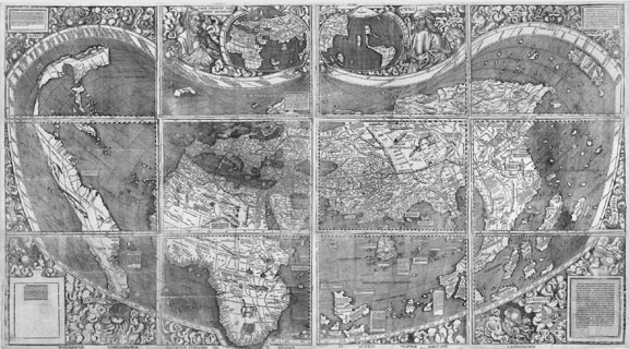
The 1507 Waldseemuller World Map
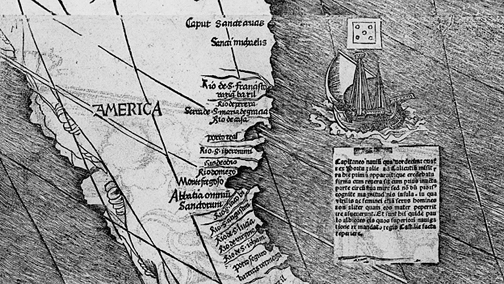
Note that on the map the name is only America and not South America. It suggests that European explorers and cartographers did not yet know the landmasses were two (Columbus allegedly explored a little of the northern part). Yet the map you see in the BBC article is not the whole thing. In the complete map you can see the northern and southern parts of America clearly, including a startlingly accurate Central America. By 1507 European explorers had already surveyed all the American continents?
In the map you can see the western side of the continents. How did Waldseemuller come to know about that? In 1507 Europeans had not yet reached the western side of the continents. Vasco Núñez de Balboa, a Spanish explorer, had only crossed the Isthmus of Panama to reach the Pacific Ocean in 1513, and he is lauded as the first European to achieve the feat. So who was not telling something?
In the BBC map you can see the large number of place names in the southern part of South America. That is close to the southern tip of the continent, near the Strait of Magellan. Yet Magellan, the first European to sail toward that area, aided by a map he acquired in Amsterdam that showed the existence of such a passageway (the above narrative has been fully acknowledged and documented in European literature), only set sail on his “globe circumnavigation” adventure in 1521, 14 years after Waldseemuller’s map. How did Waldseemuller obtain the information for his map?

The 1507 Waldseemuller World Map Central America Waterway
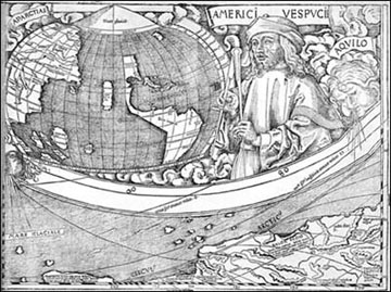
The 1507 Waldseemuller World Map Inset
In Waldseemuller’s map you can see that by 1507 he already knew about the Isthmus of Panama. Yet if you look at the inset in the map you will see that the map publisher was hesitant about his work. The geographies of the area in the two depictions in the map do not agree with each other. What gives? Maybe we do not know the details of the sham, but it does not take a high school graduate to conclude that if the map were based on real survey data there would not have been inconsistencies. The inconsistency in fact indicates that the mapmaker was copying from a source, but the source information was unclear.
In any case, the questions raised above are legitimate ones, and any student of the subject worth his two cents should spot them immediately. They are overtly apparent and should be asked. Indeed, if an expert lecturing on this map fails to bring up these questions, his competence should come into question, unless he is harboring an ulterior agenda. Regardless, a myth is still being propagated.
You can find details of such geographical fiascos, including a plausible explanation of the name America, discussed in the books The Chinese Origin of the Age of Discovery and The Hunt for the Dragon.
Please visit Mr. Chien’s incredible work here
His books and masterpiece ancient maps DVD will be added to our website shortly. For now please purchase his work here